Mapping and Geo-Science Activities
UGA and the Wormsloe Institute for Environmental History Receive the ESRI Special Achievement in GIS (SAG) Award!
On July 22nd 2015, UGA and the Wormsloe Institute for Environmental History received the ESRI Special Achievement in GIS Award at the ESRI User Conference in San Diego, California. The UGA Center for Geospatial Research was honored with this award in 2009 and was thrilled to be recognized again. Pictured below are Tommy Jordan, Jack Dangermond (President of ESRI) and Sarah Ross at the award ceremony.

ArcGIS Online Story Maps
Lana Call, Sarah and Tommy developed several ArcGIS Online Apps called Story Maps to present in the exhibit area at the ESRI Users Conference.
Mapping and Geospatial Activity at Wormsloe
by Tommy Jordan and Marguerite Madden
In Fall of 2007, early in the project, it was recognized that accurate and complete mapping of the physical, cultural, environmental and historical resources at Wormsloe would provide the solid basis for all future research. For this reason, the Center for Geospatial Research at the University of Georgia were the first researchers to be invited to come to Wormsloe and begin the mapping and documentation process. 
The research at Wormsloe, orchestrated and managed by the Wormsloe Institute for Environmental History (WIEH), was always designed to be interdisciplinary in nature: drawing together scientists and students from Geography, Ecology, History, Environment and Design, Anthropology, Geology, Forestry – all united by the concepts of time and space and the continuum of both that is represented at Wormsloe.
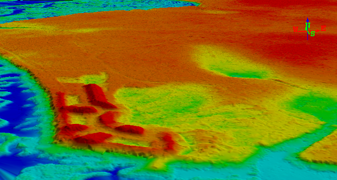
We have been collecting geospatial data using global positioning system (GPS) surveys, historical and contemporary maps and aerial photographs and aerial and terrestrial LiDAR data. These various datasets are cast on a common coordinate system (UTM, Zone 17, NAD83) and registered using ArcGIS Geographic Information System mapping and data management software. The data are organized as a series of layers in a Geodatabase and can be accessed according to date, data type or topic. A summary of the data sets is given in the table below.
GIS Datasets for Wormsloe (as of April 2013)
|
DATE |
DATA DESCRIPTION |
|
1800 |
Ila of Hope map |
|
1828 |
Plan for original Wormsloe house |
|
1870 |
Hand drawn map of roads, fields and buildings |
|
1871 |
Plan for proposed causeway to Skidaway Island |
|
1890 |
Hand drawn map of roads, fields and buildings Stereo photo cards |
|
1897 |
Hand drawn and colored map of roads, fields, fence lines, drainage ditches and buildings;Trees and plantings with species labeled |
|
1908 |
Crude map of fields and land cover |
|
1928 |
Plan for formal garden Detailed planting plan with species and plant locations |
|
1930’s |
Photographs of buildings and landscape |
|
1937 |
Blueprint of Wormsloe Fields Many photographs from Library of Congress Blueprint for remodeling of main house |
|
1940’s |
Undated low oblique aerial photograph showing house, library, dock, forest and fields |
|
1960 |
Survey plat of Wormsloe property on Isle of Hope |
|
1971 |
Air photos (0.5 m B&W) Before pine beetle outbreak |
|
1972 |
Aerial photographs (1:24,000 True color) Before pine beetle outbreak |
|
1974 |
Air photos (0.5 m B&W ) After pine beetle damage and clearing |
|
1988 |
Aerial photographs (B&W) |
|
1993 |
USGS DOQQs (1m B&W) |
|
1999 |
USGS DOQQs (1m CIR ) |
|
2003 |
Orthophotos and stereo photos (0.5 m true color) |
|
2007 |
GPS Surveys of cultural, historical and environmental features by UGA |
|
2009 |
1 m true color NAIP |
Wormsloe Butterfly Project Map Downloads
- 1908 Landcover (GeoPDF)
- 1933 Landover (GeoPDF)
- 1945 Topo Map (GeoPDF)
- 1971 Air Photo (GeoPDF)
- 1972 Landcover (GeoPDF)
- 1974 Air Photo (GeoPDF)
- 1988 Air Photo (GeoPDF)
- 1988 Landcover (GeoPDF)
- 2008 Air Photo (GeoPDF - page size)
- 2008 Air Photo (GeoPDF - large)
- 2009 Lidar Basemap (GeoPDF large)
- 2013 Butterfly Gardens Basemaps