| Map
No. |
Map
Name & Negative Number |
Author
(year) |
File
size |
| Map
1794 G4 |
Georgia,
from the latest authorities. Neg 2217 |
Barker
1794 |
216kb |
| Map
1796 G4 |
Georgia,
from the latest authorities. Neg 4911 |
Tanner
1796 |
207kb |
| Map
1796 G42 |
Georgia.
Neg 5817 |
Barker
1796? |
76kb |
| Map
1796 M3 |
A
map of Georgia, also the two Floridas. Neg 5816 |
Doolittle
1796 |
148kb |
| Map
1800 E8 |
An
exact map of North & South Carolina, & Georgia with
east and west Florida. Neg 5815 |
n.a. 1800? |
165kb |
| Map
1806 T3 |
Carte
de la Floride et de la Georgie. Neg 5241 |
Tardieu
1806 |
230kb |
| Map
1798 R7 |
A
correct map of the Georgia Western territory. Neg 2687 |
Russell
1798 |
76kb |
| Map
1805 L42 |
Georgia.
Neg 5812 |
Lewis 1812 |
104kb |
| Map
1810 G4 |
Georgia,
from the latest authorities. Neg 857 |
Scoles
1810 |
145kb |
| Map
1814 L4 |
The
state of Georiga. Neg 3806 |
Lewis 1814 |
159kb |
| Map
1822 Y6 |
Georgia.
Neg 5269 |
Young &
Delleker 1822 |
147kb |
| Map
1831 H4 |
Map
of the states of Alabama and Georgia. Neg 5288 |
Hinton
1831 |
276kb |
| Map
1824 Y6 |
Map
of North & South Carolina & Georgia. Neg 5272 |
Young 1824 |
205kb |
| Map
1829 G4 |
Georgia.
Neg 3807 |
Young &
Delleker 1828 |
149kb |
| Map
1835 M5 |
Map
of the staes of North Carolina, South Carolina & Georgia.
Neg 5294 |
Mitchell
1835 |
374kb |
| Map
LUMP1 |
Map
of the Gold Placers, in the vicinity of Dahlonega, Georgia.
Neg 5971 |
Blake ca.
1858? |
225kb |
| Map
LUMP3 |
Town0site
of Dahlonega, Lumpkin County, Ga. Neg 5259 |
n.a. n.d. |
126kb |
| Map
1882 H3 |
Map
of the Dahlonega gold region. Neg 5766 |
Hall 1882 |
341kb |
| Map
1828 G42 |
Georgia
& Alabama. Neg 861 |
Knight
1828 |
97kb |
| Map
1831 B4 |
A
map of that part of Georgia occupied by the Cherokee Indians.
Neg 3598 |
n.a. 1831 |
225kb |
| Map
1834 B8 |
Georgia.
Neg 4910 |
Burr 1834 |
222kb |
| Map
1836 G4 |
Georgia.
Neg 5297 |
n.a. 1836 |
258kb |
| Map
1838 G4 |
Georgia.
Neg 5300 |
Boynton
1838 |
311kb |
| Map
1851 B6 |
Bonner's
pocket map of the state of Georgia. Neg 5818 |
Bonner
1851 |
281kb |
| Map
1852 T4 |
A
new map of georgia with its roads and distances. Neg
5346 |
n.a. 1852 |
427kb |
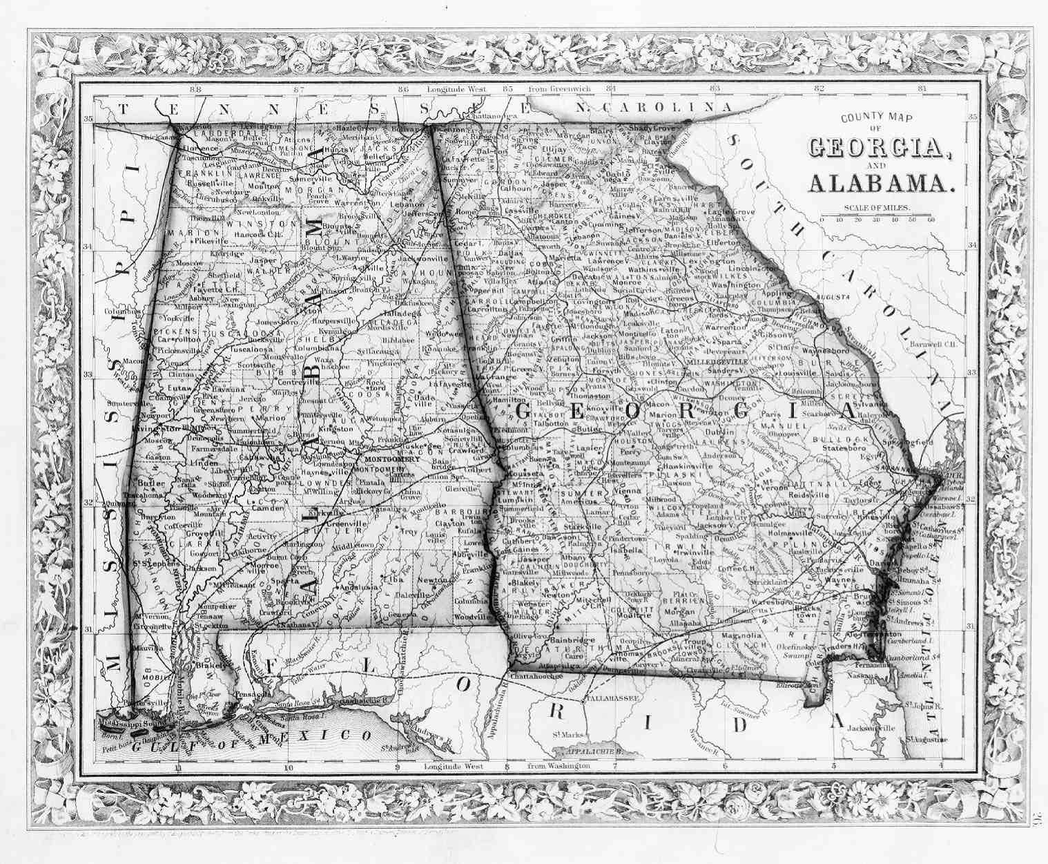
| Map
1860 M52 |
County
map of Georgia & Alabama. Neg 2530 |
Mitchell
1860 |
276kb |
| Map
1861 C6 |
Colton's
Georgia. Neg 5380 |
Colton
1861 |
385kb |
| Map
1862 J6 |
Johnson's
Georgia & Alabama. Neg 5393 |
Johnson
1862 |
510kb |
| Map
1871 B82 |
County
map of the state of Georgia. Neg 5418 |
Butts 1871 |
365kb |
| Map
1877 G6 |
Gray's
new map of Georgia. Neg 5550 |
Gray 1877 |
453kb |
| Map
1898 O3 |
Official
map of Georgia. Neg 5618 |
State Dept.
of Agriculture 1898 |
454kb |
| Map
1870 H3 |
Hanleiter's
directory map of Atlanta. Neg 5761 |
Hanleiter
1870 |
150kb |
| Map
1893 S7 |
Map
of the city of Athens, Georgia. Neg 5610 |
Strahan
1893 |
171kb |
| Map
1869 A3 |
Plot
of campus, Franklin College [i.e., the University of Georgia]
Athens, Georgia. Neg 5408 |
n.a. 1869 |
100kb |
| Map
1886 D3 |
Map
of Atlanta. Neg 5563 |
n.a. 1886 |
208kb |
| Map
1894 A7 |
Atlanta.
Neg 5611 |
n.a. 1894 |
225kb |

![Plot of campus, Franklin College [i.e., the University of Georgia] Athens, Georgia](http://www.libs.uga.edu/darchive/hargrett/maps/1869a3.jpg)
 Back
to Hargrett Library Rare Map Home Page
Back
to Hargrett Library Rare Map Home Page

